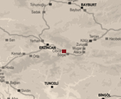
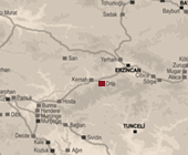
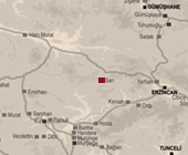
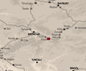
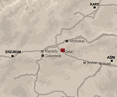
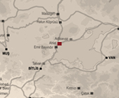
Erzincan
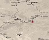
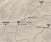
Alacahan is estimated to have been located on Balyayla village of Tercan district in Erzincan according to the map of ÇEKÜL (Foundation for the Protection and Promotion of the Environment and Cultural Heritage). On the map, six khans are showed along the Erzurum - Erzincan Road which is parallel to the Fırat River. The Alacahan which has no remains is the third one of those six khans from Erzincan to Erzurum.
While the Cibice Khan, also called as Keşiş Khan, which was encountered at numerous sources has no remains and exact location of its is not clear, it is believed that it was situated on Üzümlü district, called as Cimin at past, of Erzincan. The khan, which was also mentioned by Evliya Çelebi and Francesco Pegolotti, can be at the Cibice Pass in the Keşiş Mountains of the east of the Cimin village (Özergin, 1965). On the map of ÇEKÜL Foundation for the Protection and Promotion of the Environment and Cultural Heritage), six khans are showed along the Erzurum - Erzincan Road which is parallel to Fırat River. The Cibice Khan is the second one of that six khans from Erzincan to Erzurum.
The location of Hanbağları, known as Hanköy Khan and Başpınar Khan, is estimated as Başpınar area of Kemaliye district of Erzincan according to the map of ÇEKÜL (Foundation for the Protection and Promotion of the Environment and Cultural Heritage). Nothing remains of the khan which is believed to have been situated between Rabat and Gökçe villages which are near to the Fırat River (Özergin, 1965).
The location of the Kemah Khan is estimated to have been located on the Çalgı village of Kemah district in Erzincan by taking into account the map of ÇEKÜL (Foundation for the Protection and Promotion of the Environment and Cultural Heritage). The village is close to railroad which is parallel to Fırat River. The khan which has no remains is near to Orta Khan, but at the other side of the railroad and the river.
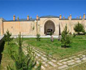
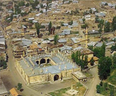
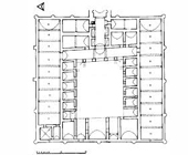
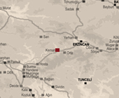
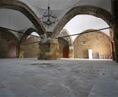
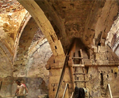
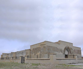
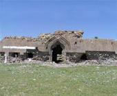
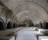
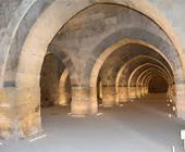
The Mama Hatun Caravanserai, also called as Tercan Khan, which is located on Tercan district of Erzincan is a part of Mama Hatun complex, comprised of khan, tomb and bath. Although the caravanserai has no construction inscription, it is considered to have been built in the Seljuk era in the late 13th century. Detailed information about the caravanserias can be found in numerous important sources. The building which has a rectangular plan in east-west direction is composed of portico and pointed vault covered areas and barn sections surrounding the courtyard which is entered through the crown gate on the axis on the east. There are six porticoes in the north and south of the courtyard and rectangular planned barn sections in the east-west direction behind them. In the west, there are three large iwans in the middle and a rectangular space covered with vaults, and in the east, there are symmetrically rectangular spaces on both sides of the entrance iwan after the crown door and two iwans that provide passing to barns. It is understood that the caravanserai was converted many times during the Ottoman era and lost its original plan characteristics.
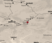
The Mugar Khan, also called as Mughisar Khan, is demonstrated as fourth khan from Erzincan to Erzurum on the map of ÇEKÜL (Foundation for the Protection and Promotion of the Environment and Cultural Heritage) which six khans along the Erzurum - Erzincan Road which is parallel to the Fırat River. While the khan, which is mentioned at articles written by Özergin (1965) and Eravşar (2017), has no remains and other informaton about itself, it is predicted to have been on Kargın village of Tercan district of Erzincan.
The location of the Orta Khan is estimated to have been located on the Uluçınar village of Kemah district in Erzincan by taking into account the map of ÇEKÜL (Foundation for the Protection and Promotion of the Environment and Cultural Heritage). The village is close to railroad which is parallel to Fırat River. The khan which has no remains is near to Kemah Khan, but at the other side of the railroad and the river.
It is predicted that the Sarı Khan, also called as Sarhan, was situated on the Yücebelen village of Kemah district in Erzincan. The village is near to the Fırat River. The khan which has no remains is only mentioned on the map of the ÇEKÜL (Foundation for the Protection and Promotion of the Environment and Cultural Heritage).
The Sörperan Khan, also known as Sörpe Khan, is predicted to have been located on Demirpınar village of Üzümlü district in Erzincan according to the map of ÇEKÜL (Foundation for the Protection and Promotion of the Environment and Cultural Heritage). On the map, six khans are showed along the Erzurum - Erzincan Road which is parallel to the Fırat River. The Zurun Khan, which has no remains, is the second one of those six khans from Erzincan to Erzurum.
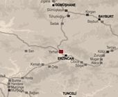
By taking account of the map of ÇEKÜL (Foundation for the Protection and Promotion of the Environment and Cultural Heritage), the location of Yerhan is estimated as Çukurkuyu village, which is next to the Sivas-Erzincan Road in Erzincan. The khan which has no remains is near to center of Erzincan.
It is predicted to the Zurun Khan, also known as Köprübaşı Khan, is located on Akyurt village of Tercan district in Erzincan according to the map of ÇEKÜL (Foundation for the Protection and Promotion of the Environment and Cultural Heritage). On the map, six khans are showed along the Erzurum - Erzincan Road which is parallel to Fırat River. The Zurun Khan which has no remains is the fifth one of that six khans from Erzincan to Erzurum.
Gümüşhane
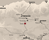
It is predicted that the Sadak Khan was situated on the Sadak village of Kelkit district in Gümüşhane. The village is near to the Gümüşhane - Erzincan Road which is parallel to Değirmen Creek. The khan which has no remains is only mentioned on the map of the ÇEKÜL (Foundation for the Protection and Promotion of the Environment and Cultural Heritage).
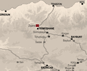
The Zigana Khan was only encountered on the map of ÇEKÜL (Foundation for the Protection and Promotion of the Environment and Cultural Heritage) and it is showed near to the Gümüşhane - Giresun Road which is parallel to Doğankent Creek. It is estimated that the location of the khan, which has no remains, was on the Budak village of Torul district in Gümüşhane.
Bayburt

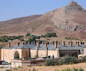
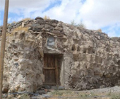
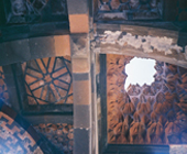
Taşhan, known as Bedesten, is near the Grand Mosque and in the bazaar in the center of Bayburt. Its inscriptions disappeared after a fire and there is not clear information about the construction time. When Evliya ÇELEBİ visited Bayburt at the beginning of the XVII. century, he mentioned the khan as "immensely fancy and elegant". The structure, covered by four domes which are carried by arches that are attached to a central leg, was built of cut stone (Yurttaş and Heidari, 2015). The Taşhan which had been used as a warehouse until recently began to host cultural events after restoration.
Erzurum
Location of the Dellal Han is estimated as Dellalhani village of Horasan district in Erzurum by taking consideration of the map of ÇEKÜL (Foundation for the Protection and Promotion of the Environment and Cultural Heritage) and the name of the khan and the village. The Dellahani village is near to the Erzurum - Ağrı Road and Velibaba Creek. There is no remains of the khan.
The Hacıbekir Caravanserai is situated in Hacıbekir Village, 35 km from the town center of Askale district in Erzurum. Since there is no inscription of the caravanserai, information about its history is not available. According to the stroy, it was built by the Byzantines in the 12th century, then it was repaired by the Seljuks and used as a caravanserai.
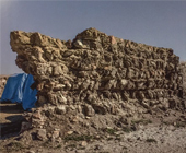
The Köprüköy Khan, known as Çobandede Khan, is located on the middle of the Köprüköy district of Erzurum. It is believed that it was built at the same time as the nearby ÇobanDede Bridge around 1300. The ruins of it is not enough to figure out the plan of the khan (Yurttaş and Heidari, 2015). Only two walls of the khan remain until today as collapsed.
Van
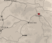
Hangeçidi was only encountered on the map of the Foundation for the Protection and Promotion of the Environment and Cultural Heritage (ÇEKÜL). There is no remains belonging the khan. It is estimated to have been located at Hanköy Village of Çaldıran in Van.
Bitlis
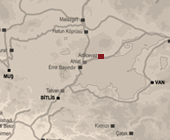
In the map of ÇEKÜL (Foundation for the Protection and Promotion of the Environment and Cultural Heritage) which is the single source mentioning Adilcevaz Khan, the khan is demonstrated next to the Ağrı-Bitlis Road, which is near Van Lake. By taking consideration of the name of khan and location of it on the map, it is placed on Adilcevaz district in Bitlis. There is no remains of the khan.
In the map of ÇEKÜL (Foundation for the Protection and Promotion of the Environment and Cultural Heritage) which is the single source mentioning Ahlat Khan, the khan is demonstrated next to the Ağrı-Bitlis Road, which is near Van Lake. By taking consideration of the name of khan and location of it on the map, it is placed on Ahlat district in Bitlis. There is no remains of the khan.
Ağrı
The location of the Doğu Beyazıd Caravanserai is indicated by Ciolek (1999) within the Old World Trade Routes (OWTRAD) Project. There is no other source mentioning that caravanserai. It is showed on Doğu Beyazıd district in province of Ağrı.
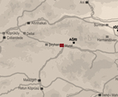
The Murathan was situated on the center of Ağrı at the intersection of the Ağrı Doğubeyazıt Road and the Ağrı - Bitlis Road according to the map of ÇEKÜL (Foundation for the Protection and Promotion of the Environment and Cultural Heritage). This intersection point is close to the Murat River flowing parallel to the Ağrı Doğubeyazıt Road. There is no remains of the khan.
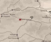
By taking account of the ÇEKÜL (Foundation for the Protection and Promotion of the Environment and Cultural Heritage), the location of Şeyhan is estimated as Eleşkirt district, which is next to the Erzurum-Ağrı Road in Ağrı. The khan which has no remains can be near the Çat Creek which is next to the Erzurum-Ağrı Road.
Kars
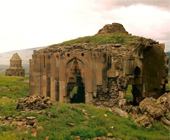
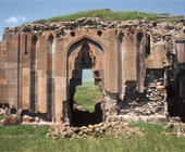
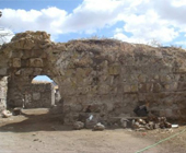
The Ani Caravanserai, also called as Seljuki Caravanserai, is located on the main street in the center of Ani Ruins which is placed in Ocaklı village of Kars. The caravanserai was constructed at beginning of 12th century by combining with Arekletos Church which was built in 10th century. Decorations of crown gate of the caravanserai reflect the original Seljuk architecture (Turkish Cultural Portal).
Iğdır
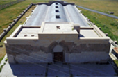
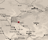
The Iğdır Caravanserai is called by many different names such as Zor Köyü Caravanserai, Ejder Khan, Şerafeddin Ejder Khan and Harmandöven Khan. The Caravanserai, which is located on the road near Harmandöven Village, fifteen kilometers from the province of Iğdır, is on the caravan road of Batumi, Ani and Doğu Beyazıt. The Iğdır Caravanserai, which was built outside the Harmandöven Village, is one of the last monumental works built by the Anatolian Seljuk State in the 13th century. These large structures, which have a castle appearance within the framework of the open courtyard and closed hall system, which were built in Anatolia within the Seljuk period, were built on important road routes, especially with the instructions of sultans and viziers. Iğdır Caravanserai as a plan built on a secondary road is differentiated from the others by having a courtyard. The Caravanserai built at the end of the 13th century, resembles the plan of İbrahim Şah Khan, which is estimated to have remained near Elazığ Çemişgezek at the end of the same century. Its courtyard was built with a closed hall system plan.
The location of the Sürmari Khan, also called as Sürmeli Khan, is indicated by Ciolek (1999) within the Old World Trade Routes (OWTRAD) Project and the map of ÇEKÜL (Foundation for the Protection and Promotion of the Environment and Cultural Heritage). It is showed on Çalpala village of Iğdır. This village is next to the Erzurum - Iğdır Road and near the Aras River.